Clouds are the handwriting of the air. They show what the atmosphere is doing right now – whether it is calmly layered or in motion, whether moisture is moving in and from which direction. Anyone who can read them knows more from a glance out of the hangar door than any forecast tells you.
Three levels and a special case
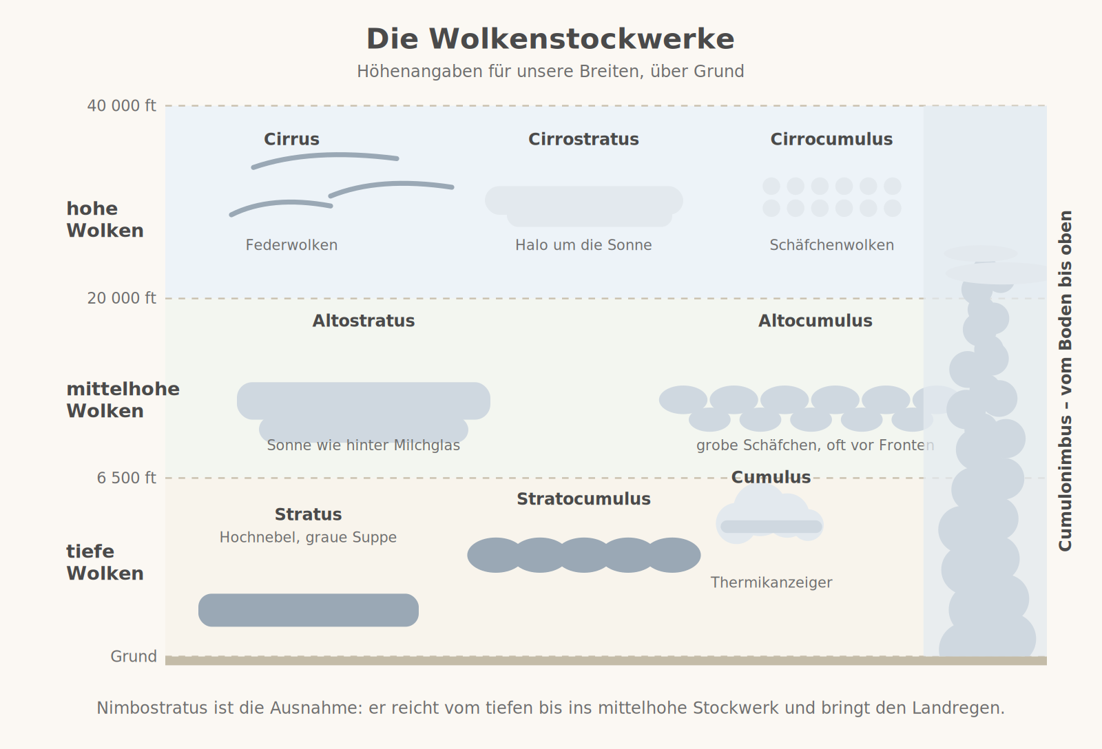
Clouds are classified by the height of their base. Over central Europe the high level extends from about 20,000 to 40,000 feet, the middle level from 6,500 to 20,000 feet and the low level from the ground to 6,500 feet. The special case is clouds with great vertical extent: cumulus and cumulonimbus grow right through all levels.
All names are made up of a few Latin building blocks: stratus means layered, cumulus means heaped, cirro- stands for high, alto- for middle level, nimbo- for rain-bearing.
What the individual clouds tell you
- Cirrus – thin ice feathers at great height. Harmless on their own. If they thicken and line up in streaks, a warm front is approaching, usually a day ahead.
- Cirrostratus – a milky veil across the whole sky. The halo around the sun or moon is its trademark and a reliable sign of a front.
- Altocumulus – coarse "sheep" at the middle level. If they stand like little towers in the morning (altocumulus castellanus), the layering aloft is unstable – thunderstorms are possible in the afternoon.
- Altostratus – a grey layer, the sun as if behind frosted glass. The warm front is close, the rain is coming.
- Nimbostratus – dark, shapeless, from the low into the middle level. Steady rain for hours, low base, poor visibility.
- Stratus – fog that does not touch the ground. As low stratus in winter it can be stable for days.
- Stratocumulus – loose grey heaps, often the remains of decaying cumulus clouds in the evening. Usually harmless.
- Cumulus humilis – the flat fair-weather cloud. It sits above an updraught and marks the thermal.
- Cumulus congestus – the cauliflower shooting upwards. It turns into the cumulonimbus.
- Cumulonimbus – the thunderstorm cloud with the anvil. Everything an aircraft dislikes, gathered in one place.
- Lenticularis – lens-shaped, smooth-edged, stationary despite strong winds. The sign of mountain waves and foehn.
Which clouds bring rain
Grey does not always mean wet. Only when a cloud is thick enough does anything reach the ground – and the type of precipitation tells you what you are dealing with. Layered clouds produce steady rain for hours, heaped clouds short, heavy showers that can be flown around.
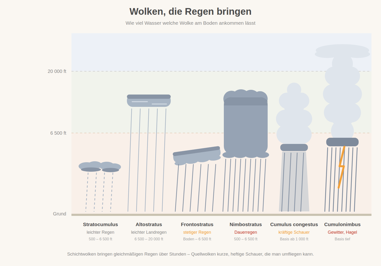
- Stratocumulus – light rain or drizzle from a broken low layer. Usually stable, and the gaps between the heaps are often large enough for VFR.
- Altostratus – light steady rain from the middle level. The halo is the early warning, six to twelve hours before it starts.
- Fractostratus – steady moderate rain immediately ahead of the warm front. The base keeps dropping; ragged cloud fragments underneath are the signal to turn back.
- Nimbostratus – steady rain for hours, solid overcast, poor visibility. Widespread, so no diversion helps, only waiting.
- Cumulus congestus – heavy showers from a cloud that is still growing. Individual cells can be flown around to the side as long as they stay separate.
- Cumulonimbus – torrential rain, hail, lightning, gust front. Give it a wide berth, never fly under or through it.
What this means for a flying day
- Flat cumuli are good news – until the circuit. They mean thermals, and thermals mean gusty air on final.
- If the cumulus clouds grow noticeably taller during the morning, bring the return flight forward. There are often less than two hours between cauliflower and anvil.
- A halo in the morning means: fly today. The front is on its way; tomorrow it will be over.
- Lenticular clouds over the mountains are a warning, not a show. They stand for strong upper winds and rotor turbulence in the lee.
- A solid stratus layer over the airfield often does not clear at all in winter. The satellite image tells you whether the deck has any holes at all.
Remember
Layered clouds mean smooth air but poor visibility. Heaped clouds mean good visibility but rough air.